


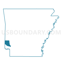
Ben Lomond Voting District, Sevier County, Arkansas
About
Outline

Summary
| Unique Area Identifier | 528204 |
| Name | Ben Lomond Voting District |
| County | Sevier County |
| State | Arkansas |
| Area (square miles) | 23.65 |
| Land Area (square miles) | 22.94 |
| Water Area (square miles) | 0.71 |
| % of Land Area | 96.99 |
| % of Water Area | 3.01 |
| Latitude of the Internal Point | 33.84668750 |
| Longtitude of the Internal Point | -94.11919590 |
Maps


Graphs
Select a template below for downloading or customizing gragh for Ben Lomond Voting District, Sevier County, Arkansas


Neighbors
Neighoring Voting District (by Name) Neighboring Voting District on the Map
- Cleveland Voting District, Little River County, AR
- Paraclifta Voting District, Sevier County, AR
- Red Colony South Voting District, Sevier County, AR
- Washington Voting District, Sevier County, AR
Top 10 Neighboring County Subdivision (by Population) Neighboring County Subdivision on the Map
- Red Colony township, Sevier County, AR (1,404)
- Cleveland township, Little River County, AR (913)
- Paraclifta township, Sevier County, AR (378)
- Washington township, Sevier County, AR (354)
- Ben Lomond township, Sevier County, AR (233)
Top 10 Neighboring Place (by Population) Neighboring Place on the Map
Top 10 Neighboring Unified School District (by Population) Neighboring Unified School District on the Map
- Ashdown School District, AR (9,717)
- Mineral Springs School District, AR (3,909)
- Lockesburg School District, AR (2,220)